| Weather Data | |||
|---|---|---|---|
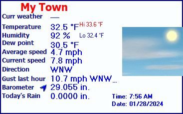
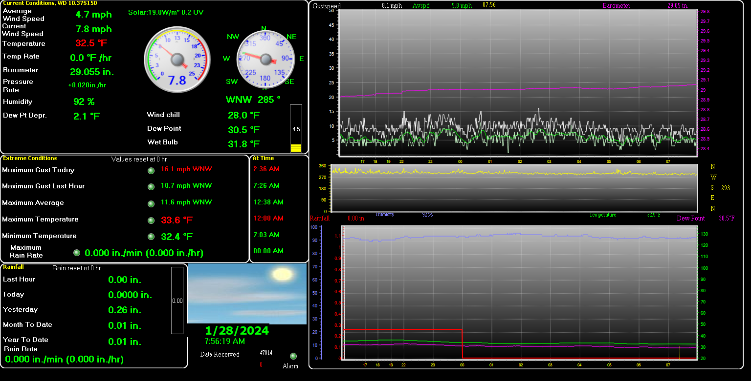
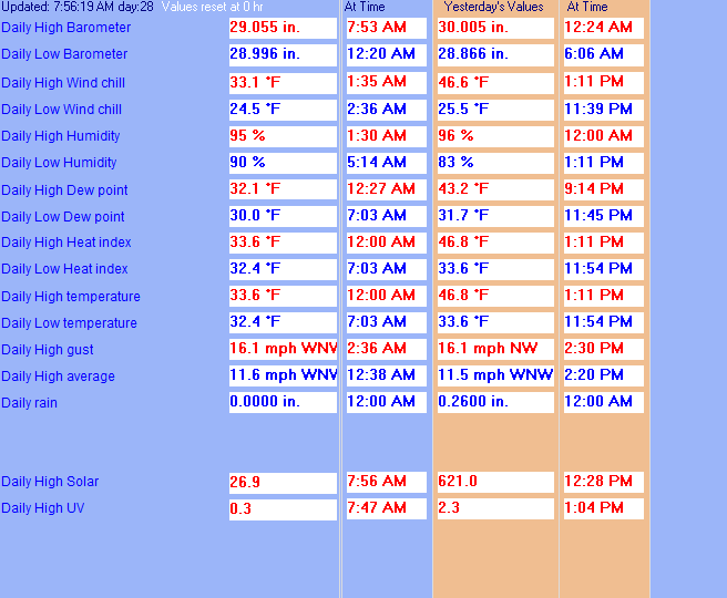
| LAST READING AT TIME: 7:55 AM DATE: January 28 2024 | |||
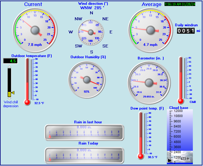
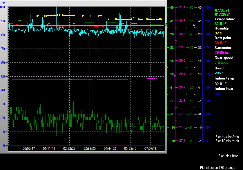
| Current Weather | --- | Current Temperature | 32.5°F (0.3°C), Apparent temp 27.0°F |
| Maximum Temperature (since midnight) | 33.6°F at: 12:00 AM | Minimum Temperature (since midnight) | 32.4°F at: 7:03 AM |
| Average windspeed (ten minute) | 5.5 mph | Wind Direction (ten minute) | WNW (292°) |
| Windchill Temperature | 27.4°F | Maximum Gust (last hour) | 10.7 mph at: 7:26 AM |
| Maximum Gust (since midnight) | 16.1 mph at: 2:36 AM | Maximum 1 minute average (since midnight) | 11.6 mph at: 12:38 AM |
| Rainfall (last hour) | 0.00 in. (0.0 mm) | Rainfall (since midnight) | 0.00 in. (0.0 mm) --- |
| Rainfall This month | 0.01 in. (0.2 mm) | Rainfall To date this year | 0.01 in. (0.2 mm) |
| Maximum rain per minute (last hour) | 0.00 in/min | Maximum rain per hour (last 6 hours) | 0.00 in/hour |
| Yesterdays rainfall | 0.26 in | DewPoint | 30.5°F (Wet Bulb :31.8°F ) |
| Humidity | 92 %, Humidex 28.3°F | Barometer corrected to msl | 29.055 in. (983.9 hPa) |
| Pressure change | +0.02 in. (last hour) | Trend (last hour) | RISING SLOWLY |
| Pressure change (last 12 hours) | +0.12 in | Pressure change (last 6 hours) | +0.05 in |
| Current 00:00 hours of sunshine today, current sky: Mainly cloudy | |||
| Sunshine hours for the year: | 12:18 hrs | Sunshine hours for the month: | 12:18 hrs |
| Current evapotranspiration 0.01 inches per day. Yesterday's reading NA | |||
Use the RELOAD facility on your browser to retrieve the latest data.